Climate
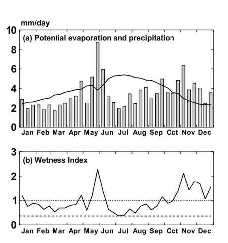 (a) Mean precipitation level for the beginning, middle, and end of each month from 1970-2001 and mean potential evaporation (solid line) on Chichijima Island
(b) Mean wetness index values for the beginning, middle, and end of each month from 1970 to 2001
(source: Government of Japan, 2010 "Nomination of the Ogasawara Islands for Inscription on the World Heritage List")
(a) Mean precipitation level for the beginning, middle, and end of each month from 1970-2001 and mean potential evaporation (solid line) on Chichijima Island
(b) Mean wetness index values for the beginning, middle, and end of each month from 1970 to 2001
(source: Government of Japan, 2010 "Nomination of the Ogasawara Islands for Inscription on the World Heritage List")
The climate of the Ogasawara Islands is subtropical with an annual mean temperature of 22.9°C. The maximum monthly mean temperature is 27.6°C in August and the minimum monthly mean temperature is 17.6°C in February. Both the annual and diurnal temperature ranges are small with high levels of humidity. The subtropical climatic zones of the Ogasawara Islands are mostly driven by the subtropical high pressure belt and the tropical air mass.
The Ogasawara Islands are located at the center of the Ogasawara High that forms at the edge of the North Pacific High, making precipitation low due to its position in a dry area with low winds and few clouds, making its interaction with typhoon rainfall very small. However, once every few decades, a large typhoon hits the islands greatly disturbing the islands and accelerates the regeneration of forests.
Although there is precipitation throughout the year, there are two rainy seasons from May-June and October-November and a midsummer drought from July-August. During the summer months, the rate of evaporation surpasses that of precipitation, and the soil becomes extremely dry during this season. However, mean monthly humidity is very high, surpassing 80% between April and September. The mean annual precipitation (1971-2000) is 1,276.7 mm. February receives the least amount of precipitation of 61.4 mm, while May receives the most precipitation of 174.4 mm.
The differences in elevation and wind direction within the Ogasawara Islands have created a wide range of climatic characteristics. There are cloud belts that develop at high elevations on tall islands like Minami-iwoto, which creates fog that allows many bryophytes, epiphytes and tree ferns to flourish. The phenology of plants reflect the tropical and temperate regions in the Ogasawara Islands with flowering and fruiting plants year round as well as some deciduous plants that drop their leaves in the winter.
