Geography
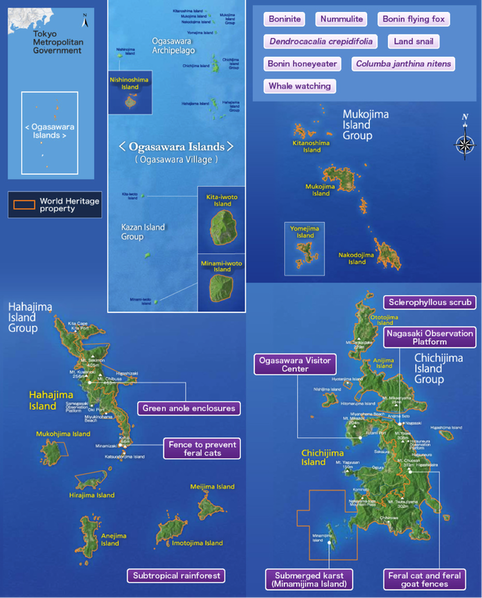 Map of the Ogasawara Islands (image: Japan Ministry of the Environment)
The Ogasawara Islands are located in the northwest Pacific Ocean, about 1,000 km south of Tokyo. This archipelago consists of over 30 small oceanic islands that are scattered across the subtropical zone between 26°40’N-27°45’N. The islands are a part of the administrative district of Tokyo and its access is limited through a 25-hour long trip on a diesel ship that embarks only once a week.
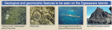
The Paleo Izu-Ogasawara Arc was formed 45 million years ago on the Philippine Sea Plate and the present Ogasawara Islands lie on top of the Izu-Ogasawara Arc that was created 15 million years ago when the Paleo Izu-Ogasawara Arc split into the Kyushu-Palao Ridge and Izu-Ogasawara Arc. It is believed that the islands were once around the equator and moved north to their position today. The islands are continuing to move north-westward at around 4 cm per year. The islands are believed to hvae been above sea-level for several million years. The largest island, Chichijima, has an area of 24 km2 and a maximum elevation at 318 m above sea level. The second largest island, Hahajima, has an area of 20.8 km2 and has the highest point out of all the islands with a maximum elevation of 453 m above sea level. Only these two islands are inhabited by people, while the other islands are uninhabited and smaller than 8 km2.
The Paleo Izu-Ogasawara Arc was formed 45 million years ago on the Philippine Sea Plate and the present Ogasawara Islands lie on top of the Izu-Ogasawara Arc that was created 15 million years ago when the Paleo Izu-Ogasawara Arc split into the Kyushu-Palao Ridge and Izu-Ogasawara Arc. It is believed that the islands were once around the equator and moved north to their position today. The islands are continuing to move north-westward at around 4 cm per year. The islands are believed to hvae been above sea-level for several million years. The largest island, Chichijima, has an area of 24 km2 and a maximum elevation at 318 m above sea level. The second largest island, Hahajima, has an area of 20.8 km2 and has the highest point out of all the islands with a maximum elevation of 453 m above sea level. Only these two islands are inhabited by people, while the other islands are uninhabited and smaller than 8 km2.
 Source: “Japan’s On-Going Nature Conservation Efforts On the Ogasawara Islands”
Due to the islands’ low annual precipitation, the islands are mostly covered by dry forest and shrubland, except for the mountain range of Hahajima Island that is covered by mesic cloud forests. The islands are mostly covered in volcanic rocks such as lava, tuff brecia, and sedimentary rocks of sandstone, mudstone, and limestone. Pillow lava is also commonly found all around Chichijima. The islands’ original topography is not clearly recognizable due to the erosion since the end of volcanic activity.
